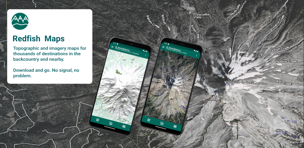
Redfish Maps
There are thousands of places where you can get away to enjoy the backcountry. These places may be deep in the mountains or just down the street, but they all provide a chance to relax, physically and mentally. Whether your interests include physically demanding activities such as backpacking or climbing or if you just want to get away, outdoor recreation sites like national parks or wilderness provide the means to accomplish this.
Redfish Maps is a member of the Outdoor Assistant™ family of apps oriented towards enhancing your outdoor recreation activities.
Redfish Maps provides seamless maps for thousands of outdoor recreation destinations. The maps are created specifically for mobile devices and are optimized for use "Off-the-Grid". The maps are in two formats:
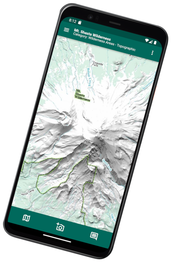
- Topographic maps are sourced from the US National Map and are styled to be consistent with the familiar USGS series of topographic maps.
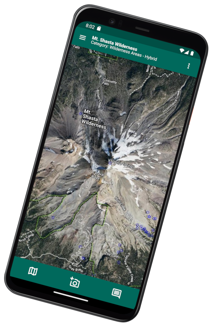
- Imagery maps are sourced from the US Department of Agriculture's National Aerial Imagery Project and are styled with a minimal overlay of place names, stream and lake names, and road and trail information.
Once a map is downloaded, all features are available whether or not a cell signal is present. Features include smooth pan and zoom, real-time GPS support, compass support including the ability to orient the map to north, take a photo that can be attached to a map location, keep a journal with the ability to attach entries to a map location, off-line geographic name search, import GPX tracks, and highly customizable map annotations.
Redfish Maps is currently available on Google Play® and coming soon to the Apple App Store®.
Map Categories
The library of available maps includes several different map categories. All categories are available in both topographic and hybrid formats. Available map categories include:
- Wild and Scenic Rivers
Wild and Scenic Rivers are streams that have been placed into protected status so as to preserve water quality, scenic values, and free-flowing status. The Wild and Scenic Rivers system began with the enactment of the Wild and Scenic Rivers Act of 1968 . Many of the streams in this program have significant recreational value. An example stream is the Clarion River which flows through the Allegheny National Forest in northwest Pennsylvania. The Wild and Scenic protections extend for 52 miles with 17 miles considered scenic and the remainder classified as recreational. Recreational access to the river is available through the Allegheny National Forest as well as two Pennsylvania State Parks.
- National Rivers
National Rivers must be free-flowing streams that have at least one remarkable natural, cultural, or recreational value. The National River program ensures that the streams remain free-flowing and also seeks to protect the immediate environment. A National River must also provide outstanding recreational opportunities such as hiking or floating. An example National River would be the Buffalo National River in the scenic Ozark Mountains of northern Arkansas. The free flowing Buffalo National River flows through 135 miles to its confluence with the White River. Approximately 95 thousand acres along the river are protected. There are numerous access points.
- Wilderness Areas
The US wilderness system began in 1964 when the The Wilderness Act of 1964 was enacted. Over 760 wilderness areas encompassing over 110 million acres are currently in the wilderness inventory. Wilderness areas are typically larger than 5,000 acres in size and represent significant regions of undeveloped land, and are primarily roadless areas. No motorized or other mechanical-based access is allowed including bicycling. Wilderness provides, perhaps, the best way to see the land as it was before factories, super-highways and subdivisions arrived. Wilderness areas are found in 44 states plus Puerto Rico. An excellent example wilderness is the Joyce Kilmer - Slick Rock Wilderness located in western North Carolina and eastern Tennessee. This wilderness protects over 19 thousand acres with about 60 miles of trails. The most outstanding feature is the Joyce Kilmer Memorial Forest with 3,800 acres of old-growth hardwood forest. The Joyce Kilmer Memorial Forest is likely the most outstanding virgin eastern hardwood forest in the United States. It is accessible via a 2 mile loop trail from the wilderness boundary.
- Parks and Recreation Areas
The National Park System contains over 400 park sites across all the states and includes parks in Puerto Rico, American Samoa, Guam, and the US Virgin Islands. There are over 80 million acres of land protected within the National Park System. The park system was first enabled in 1906 by the American Antiquities Act and the National Park Service was authorized by the Organic Act of 1916. In addition to the NPS, national parks are also administered and managed by the US Forest Service and the Bureau of Land Management. The park system has 20 different park types. The Parks category in Redfish Maps includes the following categories.
-
National Park - National Parks are generally considered to be the flagship parks for the National Park System. They usually protect multiple resources and provide a good mix of conservation and recreation. They tend to have greater numbers of visitors, but many of the larger parks also have extensive backcountry areas. Many national parks have wilderness areas included within the park boundary. They tend to be larger than other park types and usually have a higher level of development. Consider the Great Smoky Mountains National Park which is situated along the spine of the Appalachian Mountains in Tennessee and North Carolina. This park with over 500 thousand acres of area is the most visited National Park, but has thousands of acres of seldom visited backcountry with over 800 miles of trails including a 71 mile segment of the Appalachian Trail.
-
National Preserve - National Preserves are ofter associated with National Parks although there are some that are free-standing. There are almost 25 million acres in National Preserves of which 86% are in Alaska. National Preserves tend to have fewer restrictions on use than National Parks, with most allowing hunting and other activities that may be restricted in National Parks. A typical National Preserve, might be Big Thicket National Preserve in southeast Texas. Big Thicket protects nine different ecosystems while providing excellent outdoor recreational opportunities.
-
National Monument - National Monuments are usually created to protect a single significant historical, archeological or scenic resource. They tend to be smaller than National Parks. A typical National Monument, might be Montezuma Castle National Monument in central Arizona. This National Monument protects a 600-year old cliff dwelling that is remarkably intact.
-
National Recreation Area - National Recreation Areas were originally created to provide for recreation at federally constructed reservoirs. The program has since expanded to include other areas with significant outdoor recreation potential. Most NRA's are managed by the National Park Service, but some, such as the Sawtooth National Recreation Area are managed by the US Forest Service. Some NRA's are among the most visited of all the National Parks. For example, one unit of the Gateway National Recreation Area is located in the Queens Borough of New York City, just steps away from John F. Kennedy International Airport. Another example of an urban NRA is the Golden Gate National Recreation Area located just across the Golden Gate from San Francisco.
-
National Lakeshore - National Lakeshores are created for public access to water-focused recreation on large freshwater lakes. Conservation and preservation of sensitive shoreline areas and offshore islands are important goals of the National Lakeshore program. A typical National Seashore might be Pictured Rocks National Lakeshore along the south shore of Lake Superior in Michigan. The park has 15 miles of scenic cliffs along its 42 mile length.
-
National Seashore - Just as for National Lakeshores, National Seashores provide access to water-focused recreation on all the US coasts. Sensitive coastal areas and offshore islands, including fragile barrier islands are protected. An example National Seashore is the Gulf Islands National Seashore which balances recreation with protection of over 160 miles of coastal marsh, barrier islands and other marine habitat in Mississippi and Florida.
-
- Birds and Wildlife -
The premier areas for viewing birds and wildlife are the over 560 National Wildlife Refuges across the country. The refuges are managed by the US Fish and Wildlife Service and the system provides some of the best wildlife viewing on Earth. The refuges manage important wetlands, forest and other habitat for the benefit of the wildlife, but also provide for public recreational access. The National Wildlife Refuge system consists of over 95 million acres across all 50 states and 5 territories. The National Wildlife Refuge system is an important contributor to the wilderness program with over 60 wilderness areas within National Wildlife Refuges. An example National Wildlife Refuge might be the Dale Bumpers White River National Wildlife Refuge, lying along 60 miles of the lower White River in southeast Arkansas. The refuge is home to the only native population of black bears in Arkansas and represents one of the last remaining bottomland hardwood forests in the Mississippi River Valley. It has over three hundred lakes within its boundaries.
- Lakes
Lakes, both natural and man-made, represent some of the most popular outdoor recreation destinations. There are over 143 thousand named lakes and reservoirs listed in the USGS Geographic Names Information System. These lakes and reservoirs occur in all states and territories. There is always a lake nearby. Many lakes are associated with other public recreation areas such as National Forests, or National Parks. A good example of this is Theodore Roosevelt Lake. Located within the Tonto National Forest in Arizona, Roosevelt Lake has abundant recreational opportunities including boating, fishing, and wildlife viewing. During the cooler months, wildlife viewers often are able to observe migratory birds that over-winter at the reservoir. These can include Canada geese as well as bald eagles and osprey.